Surveying is all about measuring distances, angles and positions on or near the surface of the earth. Surveyors use mathematical techniques to analyse field data. Survey measurement relies on understanding two basic scientific, accuracy and reliability.
Types
- Plane surveying: Earth surface is considered a 2D plane with x-y dimensions.
- Geodetic surveying: Earth surface is considered spherical (ellipsoid) 3 dimensional
Classes
- Preliminary survey (data gathering): is the gathering of data (distances, position and angles) to locate physical features (rivers, roads and other structures) so that data can be plotted to scale on a map or plan, also include the difference in elevation so that contour could be plotted.
- Layout survey: Marking on the ground (using sticks, iron bar or concrete monuments) the features shown on a design plan features: – Property lines (subdivision survey). – Engineering work (construction survey). – Z-dimensions are given for x-y directions.
- Control survey: used to reference preliminary and layout surveys.
- Horizontal control: arbitrary line tied to the property line or HWY centre or coordinated control stations.
- Vertical control: Benchmarks: points whose elevation above sea level is defined accurately.
Different methods of surveying
- Topographic survey: preliminary surveys used to tie earth surface features.
- Hydrographic survey: preliminary surveys tie underwater feature to surface control line
- Route surveys: preliminary, layout and control surveys that range over a narrow but long strip of land (highways, railroads, electricity transmission lines and channels).
- Aerial survey: preliminary and final surveys to convert an aerial photograph into scale map using photogrammetric techniques.
- Construction survey: layout of engineering work.
- Built survey: preliminary surveys tie in features that just have been constructed
- Property surveys: preliminary, layout and control surveys determine boundary locations.
Unit of measurement
There are two main measuring systems:
English system and Metric system (SI units).
- Angles are measured by: Degrees, minutes and seconds.
- 1 revolution = 360 degrees, 1 degree = 60 minutes and 1 minutes = 60 seconds
http://faculty.kfupm.edu.sa/CE/hawahab/WEBPAGE/CE260/NOTES/1CE260%20CH%20%201.pdf
Types of survey diagram
- Servitude diagrams (powerlines, pipelines or municipal services) for registering servitudes over an existing property.
- Lease diagrams for registering long leases over portions of properties.
- Consolidation diagrams when it is required to consolidate several individual properties into one, taking out certificates of consolidated title.
- Mineral diagrams to register mineral rights separately from the land rights.
- Mining title diagrams for registering the right to extract minerals from the land.
http://csg.dla.gov.za/diagram.htm
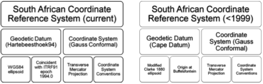
Coordinate systems
Angles of direction
Directions are measured clockwise which is the opposite for GIS data (counter clockwise).
Azimuths
- Azimuths are horizontal angles measured clockwise from any reference meridian.
- In a plane surveying, azimuths are generally measured from north/south starting at 0⁰.
- Azimuths are used advantageously in the boundary, topographic, control and other kinds of survey, as well as in computations.
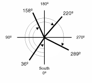
In the south azimuth system, the angles are measured clockwise from south 0⁰.
ArcGIS by default, accept angular measurements of the polar direction measuring system
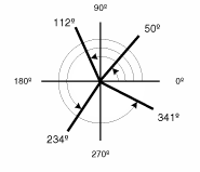
Polar angles are measured counter-clockwise from the positive x-axis, east 0⁰.
Bearing
- Assumes that total station is set up at points A, B, C, D, E, F and G; bearing read on lines AB, BC, CD, DE, EF and FG.
- AB, BC, CD, DE, EF and FG are forward bearings and the inverse will give backwards bearings
- Both the forward and backwards bearing should have the same numerical values.
One can change the direction measuring system and angular units the editing tools use on the Units tab of the Editing Options dialog box.
http://moodle.najah.edu/pluginfile.php/47169/mod_resource/content/0/Angles_Azimuths_Bearings.pdf
http://desktop.arcgis.com/en/arcmap/10.3/manage-data/editing-fundamentals/about-direction-measuring-systems-and-units.htm