Pillar safety analysis on the map:
Thinking about Lily Mine as reported by Mail & Guardian on February 15,2016, that the central pillar of ore, called a crown pillar, collapsed subsequently leading to the lamp room which was at the entrance swallowed up by the sinkhole burying three mine employees. This made me to think of the underground solutions we have implemented using 1ArcGIS for Mining to visually analyse on the map the safety factor of pillars individually and accumulatively, and be able to overlay on that single map – mine progress, surface infrastructure and all other related mine assets.
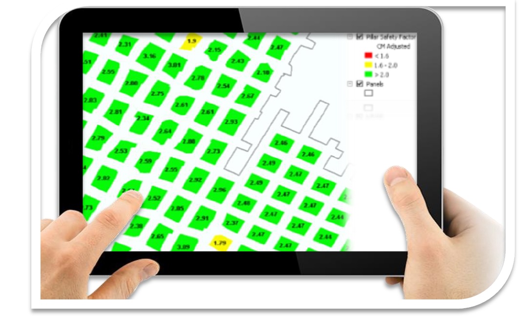
Many mine incidents recorded in the past have always been linked with pillar failure. Geotechnical engineers in an effort to predict and minimise such incidents; use proven, yet complex mathematical calculations to determine the safety factor of pillars in the mine. Most of these calculations are time consuming to replicate and difficult to display to relate them with other possible surrounding risks as well as the cumulative effect with surrounding pillars.
Applying Geography using ArcGIS has proven that it can remove technology barriers between different mine technical systems and save time to get to the answer required to making a decision. Using the application in a coal mine to calculate and display the pillar safety factor in historical workings and active areas proved to be highly beneficial. A complex geotechnical method was incorporated into ArcGIS platform with variable parameters taken into consideration including pillar shape, distance between pillars, size, material and other surface irregularities of the hanging wall and foot-wall. The pillar safety factors were easily displayed and shared to key stakeholders and accessible using any device such as iPad, enabling decision makers to make decisions wherever they were. It became much easier to replicate the model for other mines with flexibility to change parameters. The time to load new data entries and to verified them on accuracy drop from taking months into seconds.
This did not only improve the method used and data quality. It also flagged risk areas that were never considered before in the underground workings and on surface by enabling visibility of other assets that were at risk of sinkholes should a pillar collapse.
1ArcGIS for Mining is a mining focused solution leveraging ArcGIS Platform technology