ArcGIS 10.5 is on its way, with the planned release scheduled for mid-December 2016. One of the big changes coming is a new product being unveiled called Insights for ArcGIS.
So, what exactly is Insights for ArcGIS? I would like to look at it as a map centric BI tool. It allows you to perform analytics which helps you uncover secrets about your data. The data in this app is displayed on “cards”. On each card a user can display a map, chart or table with data.
I have played around with the app at pre–release stage and thought it would be nice to give you a preview before the app is released officially. I summarised some important things to know about insights as well as of my favourite things about the app.
The important things about Insights for ArcGIS:
- It is only available with ArcGIS Enterprise 10.5.
- It is a premium extension to Portal for ArcGIS with an additional cost.
- It is a web application and can be accessed through a web browser.
- You need to have an identity (Username and password) to use it.
Now for some of my favourite features about the app
1. Location is key
In most BI systems, the map card is there just to visualise data. With Insights, you have similar “mapping & visualisation” power as you would in your ArcGIS Online map viewer. This means you can create heatmaps, change symbology, set transparency etc.
In the example below I have added a card that has carjacking data collected at police stations in Gauteng over 10 years. You will note that smart mapping options included in Insights.
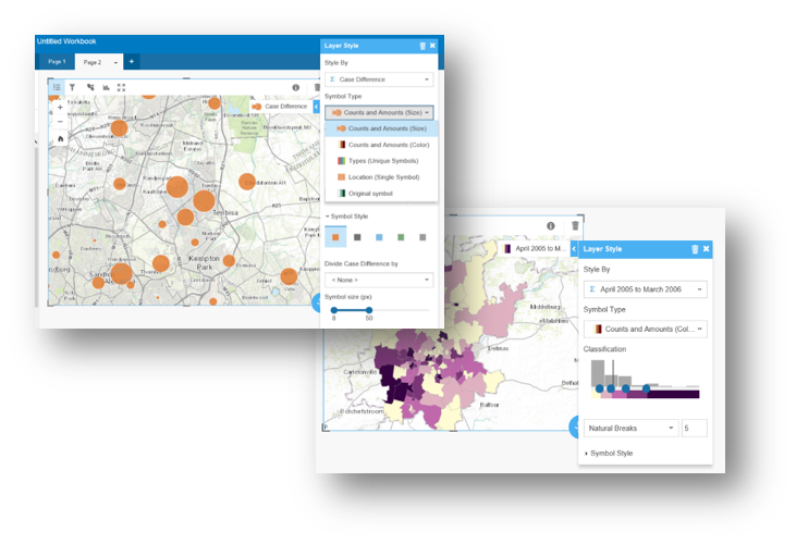
Within the card, I could change several things. The attribute field I choose to style my data by, the symbol type as well as the symbol style. With points data, you can also easily create a heatmap.
2. Multiple data sources
The real power of Insights for ArcGIS is that it allows you to pull data from multiple data sources into one dashboard view.
Currently supported data sources are:
- Web maps and feature services from your organisation portal.
- The Esri living atlas
- Databases (SAP HANA, MS SQL, Teradata …tbc)
- Excel spreadsheets
Insights is only available on Portal for ArcGIS. One of the limitations for now is that you cannot pull data from your ArcGIS Online organisational account into a card. This may well be on the future development path of the product. We will have to wait and see.
3. Document, share and re-run workflows
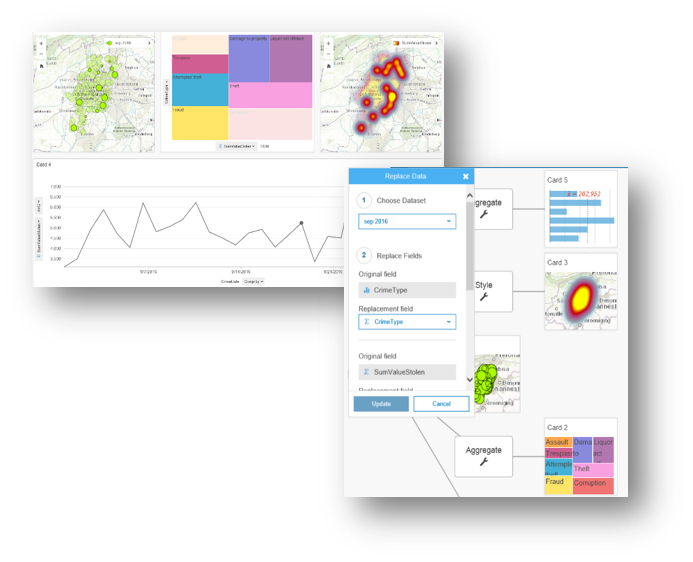
This is one of my favourite features on this app. Insights gives you the ability to document and share your analysis workflow with other users.
Remember model builder from ArcGIS Desktop? Insights has a similar tool. The only difference is that the workflow gets created for you. Below are 4 cards with different visualisations, analysing crime in September 2016 around the Johannesburg area.
As you create your visualisations, all your steps are being recorded in the background. You can switch to workflow view to see your workflows. The workflows can be shared and re-run. There is an update button that gives you the option to update the model. Here you can replace data and click update. When you switch to Page view this will then update the graphs and chart on your cards.
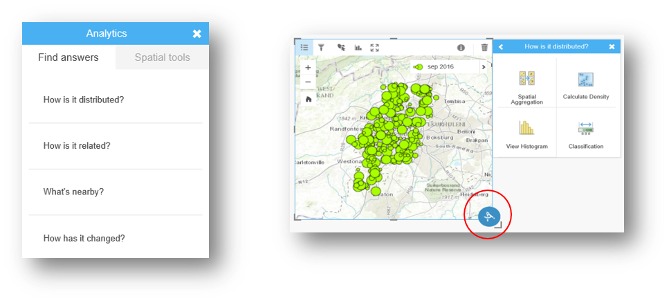
4. Questions that guide your spatial analysis workflows
As I was doing my analysis, I noticed a button at the bottom of my active card. It’s called an action button, circled in red in the image below this tool makes spatial analysis easy. The tool asks a geographical question, and uses geoprocessing tools to then answer the questions. This puts geoprocessing tools in easy to understand everyday language.
 5. Easy to use
What I love the most about Insights is the ease of use. I love the fact that tools and functionality are contextual. It’s very modern and uncluttered and has this drag and drop functionality that makes all analysis easy because it suggests tools as you pick data.
In conclusion, we live in an era where timely business information is critical to success. For a lot of our clients, ArcGIS is the system of record and business critical to their operations. Insights for ArcGIS offers a configurable BI tool specifically adapted to combine Esri’s spatial analysis platform with other record systems in your operation.
How does one get access to Insights for ArcGIS? You will need to have ArcGIS Enterprise licensed and installed on your premises. For more information regarding licensing and prices do not hesitate to contact your account manager.