Recently I found myself wondering where exactly all the space on my hard drive was going. One day it was there, and the next it was gone.
I did my usual Windows clean-up but still wasn’t happy with the outcome so I did a bit more exploring into the Esri side of things to see what could be done. And the answer, quite simply is, A LOT, with absolute minimal effort!
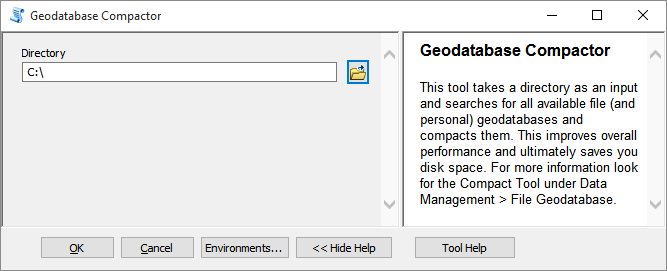
Today I am going to introduce you to a lesser known tool from the Data Management Toolbox (and definitely finding its way into my Top 10) called Compact.
The tool does what the name implies, specifically for file (and personal) geodatabases which we all characteristically have scattered across our hard drives.
The underlying architecture of these types of geodatabases relies on binary files – as you add, remove and edit data within the geodatabase these files become fragmented which ultimately decreases the performance of your database and takes up wasted space.
What compact does is rearrange how these files are stored on your disk, reducing the overall size and improving overall performance. WIN-WIN!
To explore just how much a difference this could possibly make, I wrote a script that could iterate through all of the directories on my computer, searching for these geodatabases to perform a compact operation on them. If you’re working with a specific feature class or a database is locked for whatever reason, the script will gracefully skip over it and continue on its hunt for free space in your directories. Your overall savings may vary based on the type of work you’re doing with your databases on a day-to-day basis, I personally saw a total of 70 GIGABYTES of data released back into the system. That’s a lot of 0s and 1s.
I’ve made the script into a geoprocessing tool which you can download here. If you’re the more inquisitive type, you can right click on the tool in a Catalog window and click Edit to see the nuts and bolts – it’s a very good example of Python’s os.walk function to step through files and directories.
You can choose the nuclear option like I did, and scan an entire drive, or choose a specific directory for it to iterate through.
If you have background geoprocessing enabled, progress messages will be logged to the Results Window.
Depending on the number of geodatabases you have on your PC, the first run of the tool may take some time. Subsequent runs will be faster as your databases will already be optimised.
Happy space saving!