The need to share GIS data with the public or internally in an organisation has grown markedly over the past years. Until recently, sharing data was often a manual, tedious task. Governments in South Africa have the e-government initiative requiring them to share data online. Online data sharing was achieved with the development of custom websites. If data on a custom website had to be downloaded in various different formats, it required the development of data conversion tools. This era has now, thankfully ended.
Since its release in 2014, the Open Data functionality in ArcGIS Online has made it very easy to share data and items online. Open Data allows organisations to configure a website, with their own look and feel, on which people can search by topic or location – using an interactive map- for data. This data can be downloaded in multiple formats. No coding required. It is even possible to specify who the data is shared with – specific groups in your organisation or the public at large.
Open data is a site you create using ArcGIS Online capabilities. As an administrator, all you need is some data and an ArcGIS Online organisational account. You can now also create a web portal that allows the public to access your data in 5 easy steps:
Step 1: Enable Open Data Capabilities
Open Data can be enabled within your My Organization page on ArcGIS Online. Open Data must be enabled first before the site can be configured and items shared on your Open Data site.
Sign in to your ArcGIS Online account as an administrator. Click on the “My organisation” tab, click on edit setting and in here you will click on the open data tab to enable open data.
Remember, your organisations administrator is responsible for enabling open data capabilities.

Step 2: Publish Feature Services to AGOL
ArcGIS Open Data currently works with data from hosted feature layers. Publish all the data you would like to share on your Open Data Site to ArcGIS Online as a feature service. When shared, each layer in the service will appear as an individual dataset.The following data is supported by Open Data Feature Layers, Tables, CSV files, Image Services and Documents like PDF’s or Microsoft office document. Documents will appear in the search results but cannot be previewed on an open data site. The most important thing to remember is that you are sharing your data on a public platform, therefore all data being hosted on ArcGIS Online must be publicly shared.
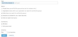
Step 3: Enable groups for Open Data Access
Publish all data for the Open Data Site to groups within your ArcGIS Online Organisational account. You can either create a new group specifically for ArcGIS Online or you can edit an existing group which you own. Make your groups available to Open Data. Make sure that Designate as available for use in Open Data sites option is checked on.
Step 4: Configure your open data site.
This is the fun part. In step 4 you will configure your open data site to suite your organisations needs. Only administrators can do this but everyone in the organisation can get involved in creating a beautiful site for your organisation. You can contribute by choosing pictures, logos or any text you would like to be featured on your site.
Going through these five tabs will help you be on your way to deploying your site.
- Site Configuration
In the site configuration tab, the administrator is responsible for setting up the name of the site, description and a URL for the site. In the latest release, users are now given the option to track and report your sites traffic using Google Analytics. In this tab, admins can also set the security of the site. Either your site can be set to private or public.

- Capabilities
In the capabilities tab, admins can specify what capabilities should be enabled on their open data site. There are two standard capabilities. Enabling Charts and enhanced search.In the latest release, Esri offers users the ability to take part in their BETA program. Seven new capabilities are set to be released soon. Administrators are encouraged to enable these capabilities for testing purposes.
If you are a user, I encourage you to explore these new capabilities. Rate them and send any ideas or errors you come across to the esri ideas portal: http://ideas.arcgis.com

- Groups Manager
Choose Open Data groups to make accessible in your site. These could be groups within your organisation or you could choose public open data groups.
- Data Manager
Data reports and management tools are provided to help Open Data Administrators identify issues with problematic datasets on your Open Data site, disable automatic download caching, and allow manual resyncing. You can see your site’s datasets by clicking the Data Manager tab from the Site Builder. Issues in your data report will be categorized into warnings or errors. When viewing your datasets, you can filter by warnings or errors and search for specific datasets.
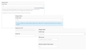
- Site Editor
The site editor allows users to design the layout of your open data site. You can design your site using the provided widgets or a custom HTML.Users simply click on the add widget button to add a new widget. The widgets can be either text, Images, RSS Feeds or Data Listings. You can change the size and location of each widget. You can delete a widget by clicking the dustbin icon.
While the design wizard experience will be sufficient for most organizations, the system also allows organizations with specific web design requirements to leverage the full power of HTML5 and CSS. The header, footer, and home page all have the option to switch to Custom HTML mode by choosing the Codetab on the correlating element, which allows web developers complete control over the content.
Step 5: Save and Share
The last step is to click on the share button and within a matter of minutes you have created your organisation very own data portal. Congratulations.
But, what about the consumer?
As a consumer of Open data, you can find data within an Open Data site by typing text into a search box or by searching the map. From the search results list, each dataset contains a summary of information about the dataset including who shared the dataset and when, when it was last updated, the number of attributes and rows in the dataset, and the first few lines of the dataset description.

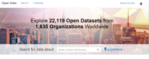
There are hundreds of open data sites and datasets across the world that have been shared for public use. To explore some of these click here: http://opendata.arcgis.com/
Go forth and explore!