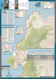
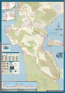
Wesgro Cape Cycle Routes
Esri South Africa’s Cape Town office was awarded a Wesgro tender to produce three paper maps of cycle routes for the Western Cape Government. The maps are intended to help promote cycle tourism in the region.
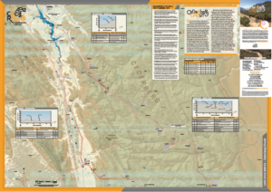
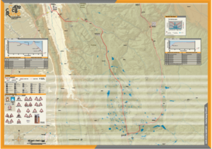
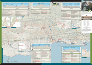
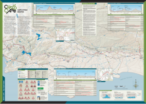
The brief was to create downloadable paper maps showing the various routes, points of interest, topography and road types. The routes covered three different areas in the Western Cape. Map furniture such as route profiles, turn by turns and text were added afterwards by a third-party designer.
Cross Cape – This route involves a 742 km ride from Plettenberg Bay to Stellenbosch or vice versa, with a difficulty level of 8/10. It can take the cyclist anywhere from 5 to 20 days to complete, with an ascent of 10 461 m through nine different mountain passes.
Cycle Tour 364 – Named after the world’s largest timed cycle race, the Cape Town Cycle Tour, the number “364” refers to the fact that the route is open 364 days of the year except for the day of the actual race. Starting and ending at the V & A Waterfront, the cycle route covers 123 km with a difficulty level of 3/10. It can be completed in 1 to 3 days.
Cederberg Circuit – This 247 km cycle route starts and ends in the citrus haven of Citrusdal. It has a difficulty rating of 6/10 and ascends 3538 m through four mountain passes. It can take the cyclist anything from 3 to 6 days to complete.