
Geographers have embraced the relatively new technology of Geographic Information Systems (GIS) in order to enhance our understanding of geographic topics around the world. Esri South Africa believes that by simplifying our world view, through the use of GIS and spatial solutions, we can enable teachers and learners to master key Geography and mapwork skills by using GIS. Through the use of exciting technology, Esri South Africa have created a means of explaining fundamental Geography, mapwork and GIS concepts to learners from grade 10 to 12.
Esri South Africa has studied the Curriculum and Assessment Policy Statement (CAPS) document relating to the Geography grade 10 -12 curriculum and, with the help of experienced Geography teachers and being industry leaders in GIS, have developed an application, called FundaLula, to facilitate the teaching of mapwork in South African schools. FundaLula has been designed by South Africans for use within the South African market, covering all of the Geography mapwork curriculum. In FundaLula, we combine short interactive lectures, videos, hands-on exercises, brainteasers and demonstrations to keep learners alert and learning. FundaLula’s use of Information Communication Technology (ICT) creates an engaging and dynamic learning environment for both educators and learners.
Spatially Empowering the Future Generation
FundaLula Support & Training
For support and training please fill out the form below and we will be in contact with you.
[caldera_form id=”CF5b3203f88adb8″]
FundaLula Teacher Notes
The FundaLula Teacher notes have been formulated to provide teachers with all the required background, resources and preparation to present specific lessons.
FundaLula activities are designed to challenge our learners. We aim to teach our learners to think critically, to solve problems and to be analytical in the way they go about reading and interpreting maps. Each lesson consists of the folowing components:
Lesson Framework
1.1. Lesson Time
1.2. Lesson Resources
1.3. Lesson at a glance
1.4. Lesson Preparation
1.5. Lesson Objectives
Lesson Content
3.1. Topic 1: Introduction to map features
3.1.1. Natural Features
3.1.2. Artificial Features
3.2. Topic 2: Map symbols
3.2.1. Symbol shape
3.2.2. Symbol size
3.2.3. Symbol colour
3.3. Qualitative and Quantitative symbols
3.3.1. Qualitative symbols
3.3.2. Quantitative symbols
Introduction
As we get a better understanding of maps, we also need to understand the objects drawn on the
map i.e. map features and the use of map symbols to allow us to differentiate between map
features.
Homework
Using the conventional sign sheet, create a table with the headings Point, Line and Polygon and
insert each sign under the appropriate heading.
Activities
4.1. Activity 1: Map Features
4.2. Activity 2: Map symbols: Shape, Color and Size (Funda Lula)
4.3. Activity 3: Importance of colours in symbols
4.4. Activity 4: Qualitative and Quantitative symbols (Funda Lula)

FundaLula News & Events
The Digital Education Africa Show hosted some of the most innovative EdTech solutions from across the globe. Esri South Africa had the opportunity to exhibit their GIS Education Platform. Our team presented live demonstrations on the functionality of FundaLula.
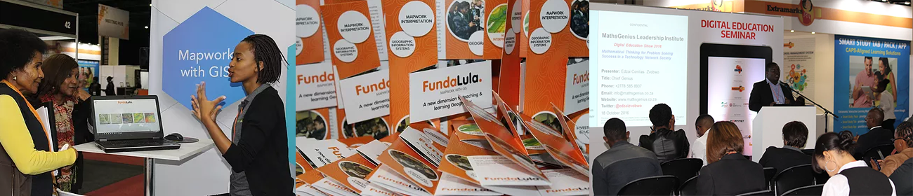
This created awareness on the importance of GIS as an essential skill, applicable in various aspects of learners’ lives. Members of our Education and Training division, Tsholofelo Diphoko and Edzai Zvobwo, presented at the Training and Development seminar on both days respectively. Topics included ‘Education through learner centred Technology’ and ‘FundaLula – Mapwork with GIS’.
This event helped establish connections with educators from all disciplines and was an excellent opportunity to introduce Esri South Africa’s position in the Education industry.
![]()
![]()
![]()
![]()
![]()
![]()
ArcGIS
- ArcGis Online
- ArcGIS Desktop
- ArcGIS Enterprise
- Mobile or Apps
- ArcGIS Developers
- Other Esri
Support
- Technical Support
- Professional Services
- Blog
- FAQ
About
- Who is Esri South Africa
- Partners
- Corporate Social Initiatives
- Publications
- Events
- Careers