Spatially aligning projects in the Kruger 2 Canyons Biosphere
Spatially aligning projects in the Kruger 2 Canyons Biosphere
What is the Kruger 2 Canyons Biospere?
The Kruger 2 Canyons Biosphere (K2C) is a UNESCO designated Man and Biosphere programme, facilitating and implementing projects aimed at promoting environmentally sustainable socio-economic upliftment and improved conservation efforts. Currently the K2C is implementing five different projects, these are:
- SANParks GEF Protected Area Programme
- SANBI GEF Mainstreaming Project
- SANParks Biodiversity Social Projects
- DEA Environmental Monitors Programme
- WWF Water Stewardship Programme
The K2C spreads across two provinces (Limpopo in the north and Mpumalanga in the south), with eight local municipalities, as well as a large part of the middle of Kruger National Park, falling within its boundaries. This is a vast landscape, spanning across 2,97 million hectares, including savannah and grassland biomes. This diversity means there is a multitude of projects, programmes and various different entities; all working towards common goals aimed at socio-economic upliftment; sustainable usage of natural resources and ecologically appropriate stewardship of the landscape.
The challenge of having such a multitude of entities operating in the K2C Bisophere across such a geographically large and institutionally complex landscape is that it makes true collective and collaborative action difficult. Through the SANParks GEF Protected Area Programme and various other projects, the K2C is currently attempting to functionally engage the broader landscape and co- champion working towards collective outcomes. The levels of nuance and continuous change in which this landscape finds itself, makes having a comprehensive prioritisation process that will align the work of all the entities in the landscape in order to achieve collective outcomes, nearly impossible to develop in a short time span and with limited funding. Through the acquisition of NPO licences for Esri ArcGIS software however, we were able to take one of the initial steps in this process. This was the development of a spatial prioritisation tool to help identify key biodiversity, ecological infrastructure, socio-economic and climate change priority areas, in collaboration with Southern Connections NPO.
Integration of Spatial Priorities using ArcGIS
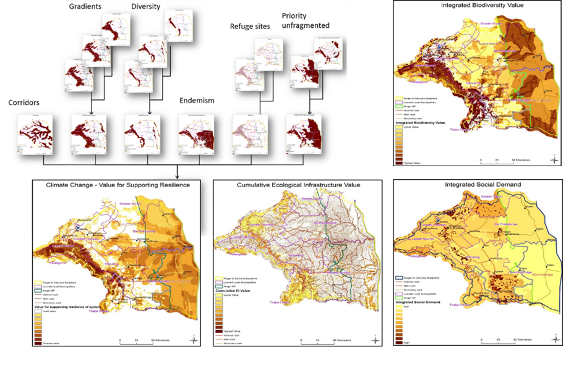
In order to more closely align the projects being implemented in the K2C landscape, geographical priorities were identified. These were developed through utilising national datasets based on the four themes. These were integrated using ArcMap 10.4, predominantly the Spatial Analyst component, as well as the Conversion Tools, Data Management Tools; Analysis Tools and others.
Below is an example of the different layers used to develop the composite dataset used to identify Climate Change priority areas through the development of a weighting system that took into consideration various factors, as listed below, to develop a composite heatmap raster. A similar process was followed to create composite layers for Ecological Infrastructure, Biodiversity Value and Social Demand.
The Result
As a result of having this improved understanding of where the priorities lie in the landscape we have been able to more closely align projects according to their key focus areas.
The Benefits
- Dramatically improved results
- Improved stakeholder buy in
- Programme complementation
- Extended implementation of time lines
- Building / stacking of programmes / projects
- Improved information sharing
To learn more about the Kruger 2 Canyons Biosphere email: [email protected]
The Challenge
– A multitude of entities operating in the K2C Biosphere across such a geographically large and institutionally complex landscape.
The Result
– Closely align projects according to their key focus areas.
Benefits
– Improved information sharing. – Extended implementation time lines.